BEFORE THE WESTERN WASHINGTON GROWTH
MANAGEMENT HEARINGS BOARD
TOWN OF FRIDAY HARBOR, et al., )
) No. 99-2-0010c
Petitioners, )
) BRIEF IN SUPPORT OF
v. ) FINDINGS OF INVALIDITY AND
) NONCOMPLIANCE AND IN
SAN JUAN COUNTY, ) OPPOSITION TO COUNTY'S
Respondent ) MOTION FOR COMPLIANCE
) FOR HEARING ON
) MARCH 6-7, 2001
____________________________________
)
MICHAEL DURLAND, et al, ) No. 00-2-0062c
Petitioners )
)
v. )
)
SAN JUAN COUNTY, )
Respondent )
)
and )
)
OPAL )
Intervenor )
)
Jointly submitted by:
|
Participant/Petitioner Maile Johnson La Porte Road Box 125 Orcas, Washington 98280 (360)376-5298 Fax (360)376-5298** |
Petitioner Lynn Bahrych P.O. Box 160 Shaw Island, WA 98260 360-428-2396 Fax 360-428-3196 |
Intervenor/Petitioner Joe Symons 3222 Point Lawrence Road Olga, WA 98279 360-376-4549 Fax: 360-376-2626 |
|
|
Table of Contents
1. (1999.10; 2001.27) Introduction: The Comprehensive Plan is inconsistent with the Vision Statement.
*2. (1999.1, 12, 13; 2001.21, 23, 24, 25, 33) Average parcel size is a relevant criterion for evaluating a Comprehensive Plan's responsiveness to and compliance with the Act's mandates and guidelines.
*3. (1999.1, 3, 12, 13; 2001.21, 23, 24, 33) Past parcelization must be considered by a county when designating densities and uses that comply with GMA.
*4. (1999.1, 13; 2001.23) The Comprehensive Plan does not provide a variety of rural densities as required by the Act.
*5 (1999.1, 3, 13; 2001.2, 21, 23, 24) SJC admits that the Comprehensive Plan encourages rural sprawl.
*6 (1999.1, 2001.21, 23, 24, 25, 33) The unintended and arbitrary rural pattern does not conserve rural character or achieve specific requirements of the Act.
*7 (1999.1; 2001.21, 22, 24) Clarification that SJC pleadings and planning documents filed in this case improperly incorporated state and federal lands and resource lands into rural lands.
*8 (1999.3, 12; 2001. 21, 29) San Juan County's resource lands are not conserved by designation or by buffering.
*9 Relief sought:
*
Abbreviations and Conventions:
Prehearing Orders
March 1999 prehearing order issues will be indicated as "1999.n", where n is the issue number;
January 2001 prehearing order issues will be indicated as "2001.n", where n is the issue number.
du = dwelling unit
1/n = 1 du/n acres, for example:1/5 = 1 du/5 acres
Exhibit Conventions:
The prehearing order of 1/3/2001, page 8, describes a preferred convention for inclusion of exhibit materials, specifically cautioning petitioners to include only numbered references from the Index, and strongly recommending that letter designations not be used to reference exhibit materials.
Unfortunately, some items that are in the Record do not have Index numbers (e.g. the Prosecutor's request that the UDC be cited directly, or the maps admitted by the order on 1/24/2001, or references to the County's Briefing materials). Consequently, and particularly mindful of the Board's admonition, we have used letter designations to refer to those items that do not have Index numbers in order to assist the Board in locating those materials within the Exhibit section. Items with Index numbers are placed at the beginning of the Exhibits and are placed in numerical order.
Participant/Petitioner Maile Johnson, Intervenor/Petitioner Joe Symons and Petitioner Lynn Bahrych oppose San Juan County's (SJC) request for a finding of compliance in 99-2-0010c, and petition for findings of noncompliance and invalidity in both 00-2-0010c and 00-2-0062c for the reasons stated below. Co-Petitioner in 00-2-0062c, Lynn Bahrych, is filing a separate brief which will address the issues not covered here.
After seven years and two hearings before the Western Board, the County continues to wrestle with challenges to its Comprehensive Plan. These stem from the fact that the CP and Unified Development Code (UDC) do not fulfill the vision, articulated in the Vision Statement, of a truly rural landscape. Petitioners believe that the BOCC chose to preserve as much of the 1979 density pattern as possible during the remand period, rather than 1) devising densities to achieve GMA and Vision Statement goals, and 2) creating an analysis of, and mitigation of, impacts from the development allowed by the CP.
As a small rural county experiencing rapid growth, SJC needs to tackle successfully problems that have not been solved by similar communities, lest it join with them in simply collapsing before the powerful forces that have elsewhere, and will here, obliterate the goals and objectives of the GMA and our community-sanctioned vision.
Petitioners assert that the densities allowed in the CP are inconsistent with the Vision Statement, the "guiding principle" of the SJC CP, as well as with GMA. (FDO) "[T]he goals policies and objectives of the Land Use Plan must be integrated with the density designation of each of the neighborhoods and the SRLUPO area. . . . A mere "consideration" of the goals, policies and objectives in the cursory manner given to such considerations in the past is not enough." Berschauer v. City of Tumwater, 94-2-0002 (FDO July 27, 1994).
SJC advances the position that population impacts of growth are experienced simply as visual impacts, and that the conservation subdivision regulations, or open space programs, adequately address these impacts.
Our position is not as sanguine: there are irreplaceable resources in San Juan County, far beyond view corridors or open spaces, that are irreparably threatened by insufficiently-considered consequences of the nature and extent of growth permitted by the CP. These resources can be preserved within the context of managed growth. As challengers, we do not wish to be devoted to demonstrating SJC’s degree of non-compliance with GMA. We have always been ready, indeed eager, to move on to create, advance, and implement constructive solutions that simultaneously achieve both Vision Statement and GMA goals.
2. (1999.1, 12, 13; 2001.21, 23, 24, 25, 33) Average parcel size is a relevant criterion for evaluating a Comprehensive Plan's responsiveness to and compliance with the Act's mandates and guidelines.
SJC has disputed the meaningful relevance of petitioners' references to average rural parcel sizes in evaluating the CP's compliance with the GMA mandates for rural densities and development. As SJC admitted in its Brief in Support of Compliance on Rural Densities and Guesthouses, page 18, average density is used in GMHB decisions evaluating whether a clustering provision would allow an intensity of use that destroys the resource that is to be conserved. Rural character and undeveloped rural land are also to be conserved under GMA and where, as in SJC, there was almost no information in the record regarding rural character and no analysis and evaluation in the record of what density of development is consistent with its preservation, consideration of average parcel size is highly significant, relevant, useful and appropriate. Diehl v. Mason County, 95-2-0073 (December 18, 1998) (used average density to determine appropriateness of limited clustering.)
An analysis of the CP that did not consider average density would be so inadequately penetrating as to be completely misleading. A county may designate land 1du/5 acres or 1du/20 acres but if, for example, the underlying, existing parcels already have an average parcel size (analogous to "pre-existing density") greater than the density designation, the underlying density must be discovered and considered in weighing the adequacy of the applicable CP density designations. To illustrate this point, to designate rural lands 1du/20 acres that already have an existing parcel size, or density, of 1du/2 acres would be meaningless planning. Averages are reasonably and justifiably used as a workable alternative to an imponderable list of the specific sizes of thousands of individual parcels. Average density, which reflects existing parcelization as well as applicable (future) subdivision parcel sizes based on the assigned density designation, thus permits discovery of actual density in a workable form.
In SJC, all rural lands (designated from 1du/5 to 1du/15) have an average density under the CP of 1du/ 4.0 acres. (#260166, line "total rural lands" at column "2000 buildout").
Forest resource lands designated 1/20 have an average density under the CP of 1du/17.9 acres. This information is relevant and necessary to a consideration of the sufficiency of regulations regarding conservation and buffering of resource lands from neighboring incompatible uses, for example. The average rural parcel size is relevant and necessary to consider when determining whether density designation and development regulations are consistent with the protection of the unique conditions of SJC's rural character, critical areas, surface and ground waters, wildlife functions and values. The county has asserted that petitioners "deceptively focus on the number of existing parcels and average existing parcel sizes." County's Brief on Compliance, November 13, 2000 line 10 page 10. Consideration of actual density is not deceptive. An analysis that fails to consider actual density may well be a charade, masquerading the allowance of costly sprawl and environmental harm as rational planning.Furthermore, the Western Board has found average density relevant and applicable in analyzing rural density. Smith v Lewis County, #98-2-0011c (FDO April 5, 1999) invalidated a uniform 5 acre rural density and stated that "[w]ithout the balance of lower, 1 to 10 and 1 to 20 densities, the extensive use of 1 to 5 and allowance of higher densities in areas of more intensive rural development (AMIRDs) creates high average densities that do not comply with RCW 36.70A.070(5) and .030(14). " (Emphasis added). Smith, supra, page 6.
The authority quoted in the preceding paragraph also negates the county's assertion that "GMA does not require the county to over compensate and raise the average lot size in rural areas to make up for existing small lots . . .in activity centers."
SJC also argued that "[t]he Act does not mandate that the County "make up" for past parcel division that did not comply with the vision of the authors of the Act. The Act is prospective in its effect and only requires evaluation of new land use patterns." County's Brief in Support of Compliance on Rural Densities and Guesthouses, lines 16-18, page 18. Such an interpretation would put the GMA swiftly out of business.
The FDO in Smith, supra at page 6 discussed the case of Hudson & Huber v Clallam County, 96-2-0031 as follows:
"In Hudson, we accepted 5-acre lots because the subdivision which had taken place in the county up to that time left no larger lots available in the 2,300-acre "developed" agricultural designated area. Still, in the "undeveloped" agricultural areas outside the 2,300 acres, we welcomed 1 du/16 acre densities."
Just as in San Juan County, Clallam County had a legacy of small lots created before GMA was enacted. "A more difficult problem for the County was presented by the 2,300 acres in the previously divided agricultural designated area. The divisions were made before the GMA was adopted in 1990." Hudson, supra at page 8, (emphasis added). Evaluation of past parcel division is essential under GMA.
Conditions preexisting GMA are not exempt from analysis during evaluation of a CP's compliance with GMA. Protect the Peninsula's Future et al. v. Clallam County, 00-2-0008 (FDO December 19, 2000) holds that "[a] county must regulate preexisting uses in order to fulfill its statutory duty to "protect critical areas" under RCW 36.70A.060(2). GMA requires any exemption for preexisting use to be limited and carefully crafted. FOSC v Skagit County, 96-2-0025 (FDO 1/3/97)." An exemption in the Clallam County Code allowing any "agricultural activity lawfully operated prior to the effective date of the ordinance" was held not to comply with GMA and in certain areas, including buffers for "major" new development and Type 5 streams, to be invalid.
By analogy, and with regard to the Act's mandate to designate rural densities that are compatible with the preservation of rural character, resource lands, critical areas and all the other functions and values to be conserved under the Act, preexisting parcelization cannot be ignored just as preexisting uses cannot be ignored. Large parcels must be preserved to balance preexisting high-density parcelization.
4. (1999.1, 13; 2001.23) The Comprehensive Plan does not provide a variety of rural densities as required by the Act.
RCW 36.70A.070(5)(b) and (c) require a CP to contain a rural element, including lands that are not designated for urban growth or as resource lands, where a variety of rural densities are provided in a manner consistent with the protection of rural character.
The Official Maps show rural density designations of 1du/ 5, 10, 15, and 20 acres. The single rural parcel designated 1du/20 acres is itself less than twenty acres and does not materially alter the variety of densities offered. Thus this brief will not again refer to this single parcel as constituting a rural density designation of 1du/20. This position was taken by the County's Brief in Support of Rescinding Findings of Invalidity which, at line 17 page 3, stated that "the rural district density allowances outside of AMIRDS provide a variety of 5, 10, and 15 acre densities and no longer substantially interfere with the goals of the GMA."
Contradicting its first brief, the County's Brief in Support of Compliance on Rural Densities and Guesthouses (SJC Brief 11/2000), which presented the substantive argument on this issue, states inaccurately that there are six rural densities consisting of: "no residential development" (in Conservancy lands), 5, 10, 15, 20 and 40 acres densities. The County claims that the CP affords a GMA-compliant variety of rural densities based on this inaccurate statement of what the rural densities actually are. "Contrary to Petitioners' claims, this table shows that San Juan County has a rural mix similar to the variety upheld in Cotton v. Jefferson County, supra." SJC Brief 11/2000 at line 12 page 10. Of the six rural densities asserted by the County's Brief, three do not in fact constitute rural densities on the Official Maps: the "no residential development" designation of state and federal Conservancy lands, 1du/20 acres and1du/40 acres. The latter two density designations occur only in state and federal lands or in resource lands.
The County's Brief describes the Petitioners as arguing "deceptively" regarding the available densities. Line 10, page 10, SJC Brief 11/2000. Rather, the County has misrepresented the densities actually included in the Plan. We must trust this was done totally in error. Petitioners too have labored under the serious, time-consuming and obscuring impediment of inaccurate, conflicting or wholly absent information on such basic facts as extent of rural acreage, acreage of density designations in rural as opposed to resource lands and rural density at buildout under the CP. A stipulation between the parties now admits some land use data on the CP into the record. #260165-260171. Nonetheless it must be noted that, for purposes of argument to the Growth Management Hearings Board in November, 2000, an extremely misleading and inaccurate characterization of the rural densities has been presented by SJC.
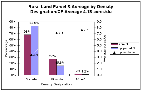
It is an undisputed fact that a significant percentage (24%, supra) of rural lands have already been subdivided to invalid densities. Staff Report page 9, #230414. Nevertheless, the County's Brief in Support of Rescinding Invalidity dated October 16, 2000, stated at page 3 that the variety of rural density in the CP includes 5, 10 and 15 acres. In fact, these are the density designations; they are nowhere near the actual densities. Due to existing parcelization and small existing parcel sizes, the supposed variety of density provided in the rural area is illusory. In reprinting a Planning Department table at page 10 in its Compliance Brief of November 13, 2000, the County omitted the third column of that table which shows that the average parcel size in Rural 5 is 4.7 acres, that Rural 10 is already 8.8 acres and that Rural 15 is already 8.2 acres. These figures have since been revised downwards. The figures are calculated by dividing the acreage of each relevant density designation of Total Rural Lands by the number of potential units under the column heading "2000 designation". The most recent information from the Planning Department indicates that the CP allows development such that the average parcel size in Rural land designated 1du/5 is 3.4 acres, that the average parcel size in Rural land designated 1du/10 acres is 7.1 acres, and that the average parcel size in Rural lands designated 1du/15 is 7.6 acres. #260169,) Thus the range of average rural density afforded by the CP is from 1 du/5 acres to 1 du/7.6 acres.
Case law is decisive that existing densities greater than 5 acres per unit (i.e. parcels of less than 5 acres per unit) do not add to rural density since they are inherently non-rural.
"An argument that the requisite variety can be provided by lots more dense than 1 to 5 (which we have typically found to be non-rural densities) is without merit, particularly when a county's rural characteristics accommodate a variety of less-dense lot sizes."
Smith v Lewis, 98-2-0011c, FDO (April 5, 1999) page 7.
The existing and CP range of densities is graphically illustrated using SJC Planning Department data subject to a stipulation agreement:
The graphic here shows both the limited range of CP densities (1/5 to 1/15) as well as the relative weight of those density categories in the CP. Here, the overwhelming majority of parcels and acres in SJC rural lands are 1 du/5 acre. The small triangles show the CP average acres/du; as noted, all of the aveage densities are substantially less than their respective size category.
A range of density from 1 du/5 to 1 du/7.6 acres is an audibly far cry from CTED's admonishment that 10 and 20 acre parcels should predominate, and is flagrantly noncompliant with GMA where, as here, so many large parcels exist. Butler v. Lewis, supra. As discussed below, were 1du/10 and 1du/20 acre densities to predominate, the average rural parcel size would be at least 8 acres, not the 4 acres afforded by the CP. The hypothetical computation of the CTED guideline shown in section 5, below, is also merely a numerical preliminary, a step taken to assure compliance with a minimum threshold, and undertakes no consideration of the impacts of that degree of development and the conservation of large parcels that might be necessary for the preservation of critical areas, rural character, water, etc. as required by GMA.
Even in the small portion of the rural area designated 10 and 15 acres per unit, 10 and 20 acre parcels would not only not predominate, they would be rare and extinct, respectively. The density in those lowest density areas alone (1 du/7.1 and 1 du/7.6 acres) would be greater than the recommendation by CTED of an average of 8 acres per unit for the entire rural area. Thus the supposed variety of rural density afforded by the CP is so vanishingly inadequate as to be nearly invisible. A range of actual density from 1 du/5 acres to 1 du/7.6 acres per unit is so remote from GMA's intention as to be preposterous in a county such as SJC, whose rural characteristics accommodate parcel sizes of 60, 80 and even 100 acres in size. Data submitted by Petitioners shows there are thousands of rural acres in parcels 40, 60 and 80 acres in size. SJC's CP affords not a "variety of rural densities" compliant with GMA but a recipe for uniform sprawl and obliteration of rural character, erosion of resource lands, and a blockade of the future expansion of UGAs.
"If Petitioners have shown in the record that a pattern of significant blocks of large lots remains, we have consistently found that the GMA requires those be protected from the inappropriate conversion of this undeveloped land into sprawling, low density development." ICCGMC v Island County, 98-2-0023c, (CO October 12, 2000). Petitioners have presented evidence that over 1100 parcels of twenty acres and larger exist in rural and resource lands in San Juan County, approximately half in each designation. ("Extract of Information from SJC Assessor's Database of Parcels 20 acres and Larger", Exhibit 20 to Symons Brief and "Rural Lands (as determined by use codes) in San Juan County that are 20 acres or Larger in Size", Exhibit A to Johnson Second Motion to Supplement, which exhibits are incorporated herein by reference.)
Exhibit B is a map that illustrates parcels divisible under the CP. Parcels twenty acres and larger, in rural and resource lands are color coded and as the map indicates, the pattern that these large parcels presently compose is not only in concentrated blocks but concentrated as functional buffers to existing resource lands. All of these parcels, whether rural or resource designated, are relevant here because SJC's BOCC intends to consider redesignation of all resource lands, thus potentially converting them to higher density rural lands. Resolution 104-2000, #244500,
The high, non-rural and functionally uniform densities in the rural area are exacerbated by redesignation of resource lands to rural land. WEAN v Island County, 95-3-0071 (April 10, 1996) and Smith v Lewis County, 98-02-0011c (July 13, 2000) held that provisions that allow "liberal opt-out" or ready redesignation of resource lands to rural, exacerbate the lack of variety of rural densities and the urban density of the rural area. This is directly analogous to the situation in SJC where the county has stated its intention to reconsider designation of agricultural and forest resource lands, and has shown, in the recently invalidated resource land redesignations, an inclination to honor landowners' requests for redesignation. Indeed the situation is worse under the SJC CP, which permits an average non-rural parcel size of 1 du/4 acres in the rural area, then that invalidated in the Lewis County CP which was a rural designation of uniform 5 acre parcels.
The Island and Lewis County cases just cited have held that this conversion of resource to higher density rural lands must be considered when evaluating the rural mix of densities. In SJC, failure to conserve resource lands (by redesignating them) will always be accompanied by the designation of the land for development at significantly higher density, most often 1du/5 acres, by far the most common rural density designation. There has been no analysis of the extent of the impact of this potential for increased density on the variety of rural densities, though the impact will obviously be to erode variety of density. SJC's CP fails to provide the requisite variety of rural densities, providing instead a uniformly non-rural density of 4 acres per unit (this density does not reflect existing or future guesthouses nor other density increasing bonuses), which would be further exacerbated by redesignation of resource lands.
One important reason for the Act's requirement of a variety of rural densities is to permit future expansion of urban growth areas. Vashon-Maury v King County, 95-3-0008 stated that density greater than 1 du per 10 acres would receive close scrutiny to ensure the number, location and configuration of lots did not establish a pattern of urban development, threaten resource lands or critical aquifer recharge areas, or thwart the long term flexibility to expand urban growth areas.
In Smith v Lewis, 98-2-0011c (April 5, 1999) the Western Board wrote:
Regarding inherent difficulties with unvariegated rural densities, Lewis County Special Deputy Prosecuting Attorney Mackie himself noted that "Thurston County is going to choke over the 1,000 five-acre tracts that were created right after it did its urban growth boundary because when it goes to move, it is going to be very hard to move through those." He characterized 1 to 5 as "one of the most wasteful land use patterns you can find."
SJC has now designated two new UGAs in Eastsound and Lopez Village, but it has failed to buffer them with densities lower than 1 du/5 to permit them the flexibility to expand in the future. These newly designated UGA's are ringed almost exclusively by a combination of shoreline and unvariegated 5 acre/unit density-designated rural land. Perhaps 10% of the boundary of the Eastsound UGA is with resource land designated 1du/20 acres. Official Maps. Clearly the necessity to afford UGA's flexibility to expand has not been considered and applied in accordance with the Act. Rural 5 was found to "thwart the county's long term flexibility to expand the [Gig Harbor] UGA" in Peninsula Neighborhood Association v Pierce County, 95-3-0071 (FDO March 20, 1996) page 19.
Failure to provide for a variety of rural densities, ready redesignation of resource lands, failure to conserve large parcels, and failure to evaluate the costs and impacts of density fail to comply with the GMA and substantially interfere with goals 1, 2, 4, 8, 9, 10, 11, 12, 13 and 14 of the Act.
5 (1999.1, 3, 13; 2001.2, 21, 23, 24) SJC admits that the Comprehensive Plan encourages rural sprawl.
RCW 36.70A.020 (2); .070(5) and .030(14) .110 require that only rural development be allowed in rural areas.
The SJC Planning Department has determined that the CP allows a rural density which SJC admits constitutes sprawl. SJC admitted in its Brief on Support of Compliance on Rural Densities and Guesthouses, filed November 13, 2000, that "sprawl represents suburban densities between 4 du/acre and 1du/5 acres." Lines 22, 23 at page 16.
SJC has determined that the CP allows an average rural parcel size of 1 du/4 acres #260166. This finding establishes that the CP allows non-rural densities in violation of the Growth Management Act. In fact, SJC has determined that designated rural lands have an average existing parcel size of 5.2 acres/du without including guesthouses, and thus an existing density that, by its own admission, virtually constitutes sprawl. #260166.
SJC Planning Staff found a 12% impact on density from the guesthouses it estimates exist on 26% of parcels with single family residences. Order Rescinding Invalidity, Findings of Fact #9, page 14. If the uncounted 12% density factor attributable to guesthouses is added to existing density, the existing average rural density is determined to be 1 du/4.6 acres, which is a density significantly greater than that which SJC admits constitutes sprawl. (SJC land use table, #260166, shows existing rural density of 1du/5.2 acres. In the same line it also shows the figures from which it determines this density, namely that there are 12,588 parcels on 65,331 rural acres. 12%–the guest house factor–of 12,588 is 1,510 which when added to 12,588 equals 14,098 density units in 65,331 rural acres from which the average density of 4.6 acres per unit is determined by division.) SJC should be estopped from denying that present density constitutes sprawl. SJC is so far subdivided that its existing density constitutes what the County admits is sprawl.
Fifty-five per cent of existing rural parcels are presently undeveloped #230347. Development of existing parcels will bring this sprawl to life, with all of its attendant costly and harmful impacts, without the creation of another single parcel by subdivision. As noted in the September 8, 2000, SJC Prosecuting Attorney's Legal Review of the CP amendments, SJC can grow at the OFM projected rate for 24 years without creating a single new parcel, #250223
"Densities lower than one unit per 10 and one unit per 20 acres . . .should predominate in the rural area." (CTED, quoted in Smith v Lewis County, 98-2-0011c, FDO page 6 (April 5, 1999)) What would it mean for densities lower than 1du/10 and 1du/20 to predominate as CTED admonishes? The Random House Dictionary defines predominate thus: "(1) to be the stronger or leading element; preponderate; prevail . . .(2) to have or exert controlling power (often followed by over) or (3) to surpass others in authority or influence." Mathematically for densities of 1du/10 and 1 du/ 20 acres to be the leading elements in a density pattern, to exert controlling power over the other rural density designations, and to surpass those other rural density designations in influence, they would have to be in the preponderance, which Random House defines as "superiority in weight, power, numbers, etc." The cumulative density effect of 1/10 and 1/20 is 1/15. For densities of 1/10 and 1/20 to be superior in power and numbers to the other rural densities they–or their cumulative, numerical equivalent, 1du/15–would have to be applied to more than half the rural lands. In contrast, the SJC CP applies densities of 1du/15 acres or lower to just 2.2% of rural lands. SJC tabular information in #260166 shows there are 65,331 acres of rural lands excluding state and federal lands, and in #260169 shows there are 1,445.3 acres of rural lands with densities of 1du/15. (This table includes state and federal lands, so the percentage may be even lower.)
The following hypothetical example illustrates the CTED guideline further. If out of a total of 290 acres, 100 acres are designated 1du/20 acres, 50 acres are designated 1du/10 acres and 140 acres are designated 1du/5acres, then 150 acres would have an average density of 1du/15 and would just barely predominate over the 140 acres designated 1du/5 acres. The average parcel size of this hypothetical 290 acre area in which the 1du/10 and 1du/ 20 acre densities just barely predominate, is 1du/7.63 acres.
|
Acres |
Potential dwelling units |
|
|
100 acres |
1du/20 acres |
5 du's |
|
50 acres |
1du/10 acres |
5 du's |
|
140 acres |
1du/5 acres |
28 du's |
|
290 acres total |
38 du's total |
= average density 1 dwelling unit per 7.63 acres.
The hypothetical just given does not comply with CTED's guideline, because CTED provides that densities lower than 1/10 and 1/20 should predominate. Thus an average rural density lower than 1du/15 acres should predominate and the average density of 1du/7.63 acres would not comply. One can change the hypothetical to achieve compliance with the CTED guideline by substituting a designation of 1du/15 for the 50 acres designated 1du/10 as follows:
|
Acres |
Potential dwelling units |
|
|
100 acres |
1du/20 acres |
5 du's |
|
50 acres |
1du/15 acres |
3 du's |
|
140 acres |
1 du/5 acres |
28 du's |
|
290 acres total |
36 du's total |
= average density 1 dwelling unit per 8 acres.
The average parcel size of the 290 acre area in which densities lower than 1/10 and 1/20 just predominate is now 1 du/8 acres. Thus under this hypothetical an average density of 1du/8 acres would just comply with CTED's guideline. In contrast the SJC CP permits a rural density of 1 du/4 acres, or double CTED's recommended maximum rural density.
Achen v Clark County, 95-2-0067 (February 5, 1998) held that uniform 5-acre parcels are invalid if greater parcel sizes would provide greater variety, would decrease sprawl and would increase resource land conservation, all of which would occur in SJC if there were no further subdivision in the rural area.
The CP permits the creation of 30% more rural parcels than exist today. #260166. (In the line, Total Rural Lands, 16,413 potential minus 12,588 existing parcels equals 3825 which equals 30% of the 12,588 existing parcels.) Obviously, a substantially lower density designation of rural lands would decrease sprawl. SJC is a text book case of the potential for sprawl that the Act was designed to prevent, sprawl that the Act requires be stopped.
Rural land parcels which are subject to subdivision under the CP are shown in Exhibit B, a map entitled "Divisible Rural Parcels and Resource Parcels Rated According to Current Size"
. The darker the shade of green the larger the rural parcel is at the present time, including parcels 100 acres and larger in size. Under the CP all of these parcels are on the chopping block. The land they comprise would be reduced primarily to 5 acre parcels. A few would be fractional fragments of their former selves in parcels of 10 or 15 acres.In addition to the map, two graphic illustrations demonstrate these points.
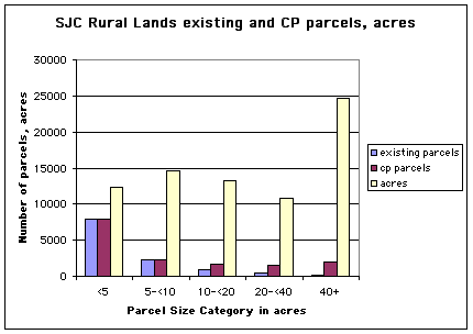
The graph shown above illustrates the number of existing vs CP parcels along with total acres in each of 5 parcel size categories. The change in the number of parcels between existing and CP conditions is essentially non-existent for small parcel sizes (parcels less than 10 acres), because such parcels cannot be subdivided. As the size of the parcel grows, however, the difference between the number of parcels under the existing conditions and in the CP grows dramatically. Most importantly, the large parcels (40 and greater acres in size), comprising the largest acreage by far (about 33% of all rural land acres) would suffer the greatest parcelization. This change is illustrated in the following chart, using the same data source:
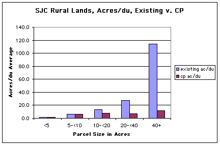
Data from #260170, SJC Planning Department, 1/9/2001, "Land use designations by use and parcel size, rural and resource lands (continued)"
Here, the average size of the parcel falls precipitously as the size of the parcel increases, between the existing condition and the CP. In particular, the large (40 plus acres) parcels suffer the greatest average acreage change, from an existing average of 114 acres/du to 12 acres/du in the CP, this, again, on one-third of the total rural land acres.
Petitioners have introduced evidence that there are thousands of acres of lands in parcels 20 acres or larger, all of which would be divisible, primarily to 5 acres. Thus the average parcel size of 1du/4 acres allowed by the CP clearly has incomparably less variety of density than exists at present. Were no further subdivision to be allowed henceforth in SJC, the average rural parcel size of 5.2 acres that exists today (this number does not include the impact of SJC's analysis of existing guesthouses) would remain nearly twice as dense as CTED recommends, but it would at least include a genuine variety of rural density. Under Achen, further subdivision should be prevented.
The Official Maps establish that in SJC, miles of resource land boundaries are shared with lands with existing densities per se urban (<5 acres/du) or that are or may be subdivided to 1 du/5 acres. Exhibit C is a map illustrating the extent of the failure of the CP to buffer resource lands as required by the Act. The map illustrates, by highlighting in contrasting colors, both the existing parcels which are less than 10 acres in size that adjoin resource lands and the potential inherent in the CP for the creation of substantially more 5 acre parcels adjoining resource lands. Under Achen, the SJC density designations should be invalidated and, to preserve resource lands, further creation of sprawl by subdivision halted.
Comprehensive Plan density designations allowing further subdivision in SJC should also be invalidated under Smith v Lewis, 98-2-0011c, FDO (April 5, 1999) in which a uniform 5 acre rural designation was invalidated. SJC's presently-existing rural density is virtually that allowed by a uniform 5 acre parcel size throughout the rural area; it is presently at 5.2 acres per unit, even without including any density factor for the 12% density impact of existing guesthouses, or for the other density-increasing exemptions and bonuses, such as the open-space residential bonus provision, the tenancy-in-common exemption, and rural residential clusters, much less the subdivision permitted by the CP. Footnote 3, #260166. Any further subdivision in SJC encourages sprawl but particularly the 5 acre per unit density designation extends and exacerbates sprawl. The County's brief states that the 5 acre/unit density designation applies to 57.54% of rural lands; upon exclusion of state and federal from rural lands, the 5 acre designation applies to 68% of the rural area, or 43,450 of 63,616 total rural acres. (The first figure is for total rural lands designated 1du/5acres, #260169; the second figure is for total rural lands, #260166,.) Thus 68 % of rural land has an average density today of 4.6 acres per unit and an average density potential under the CP of 3.4 acres per unit.
SJC has admitted that present density virtually constitutes sprawl; that the CP allows a 30% increase in the extent of this sprawl; that it has adopted a CP which allows a density higher than sprawl; and that the CP allows a population 448% of what it is today (57,559 rather than today's 12,846), with 72% of that total population allowed in the rural area (41,830 of 57,559 people, SJC Planning Staff Table, #231432,) This population projection assumes zero additional population is attributable to guesthouses, and assumes 50% of shoreline parcels will remain undeveloped. (Fn. 2 to #231430 which calculates the rural parcel total used in #231432.) The impact of this extreme population increase on the rural character, capital facilities, economy, water, wildlife and anadromous and other fish of the county has not been evaluated. The resulting density of 1 du/4 acres is not a rural density and it does not even include existing guesthouses. The potential doubling of structures due to the currently unresolved guesthouse land use policy would create an effective density of1 du/2 acres.
Further subdivision will consume the larger parcels that would, if all preserved, balance density in the rural area so as to retain the existing rural density which is 1du/5.2 acres without existing guesthouses and 1du/4.6 acres if existing guesthouses are included. There are in SJC 15,210 acres in existing parcels of less than 5 acres in size and that average 1.66 acres in size. (SJC Planning Staff Report, April 14, 2000 at page 9, #230413) These per se urban densities cover 24% of rural lands. (15,210 is 24% of 63,615.9 total rural acres, #260166). SJC must conserve its larger parcels to avoid excessively high, non-rural density and to preserve undeveloped rural land from conversion to sprawl. Smith v Lewis, 98-2-0011c, page 7 (FDO April 5, 1999) citing Achen v. Clark County , 95-2-0067c (CO February 5, 1998). As in Lewis County, SJC has excessively "high average rural densities" that do not comply with GMA. Smith, supra, page 6. Any further subdivision in SJC constitutes the inappropriate encouragement of sprawl.
The rural densities allowed under the CP
substantially interfere with goals 1, 2, 8, 9, 10, 11, 12, 13 and 14 of the GMA.6 (1999.1, 2001.21, 23, 24, 25, 33) The unintended and arbitrary rural pattern does not conserve rural character or achieve specific requirements of the Act.
The Act intends a conscious and mutually reflective composition of rural and resource lands. The intended symbiotic relationship is to conserve resource lands. Rural density is to be composed so as to conserve critical areas and to preserve rural character. (Achen v Clark, Butler v Lewis, cited and discussed in the Johnson Brief of November 14, 2000 in Opposition to Rescission of Invalidity..) RCW 36.70A.030(15) defines the term "rural character" as a pattern of land use and development "in which open space, the natural landscape and vegetation predominate over the built environment…(quotation limited for brevity)"
The rural density pattern in the SJC CP is unintended, unchosen, unplanned, and is merely the leftovers from the 1979 Plan densities. There is no provision for compliance with .070(5)(c)(5) by the buffering of resource lands with low densities in adjoining rural lands. This is discussed separately in section 8 of this brief.
To construct a density pattern to conserve rural character necessitates an appraisal of the rural circumstances. Butler v Lewis, 99-2-0027c (June 20,1000)
There is no record of surveying and appraising surface and ground water resources, traditional visual rural landscape, functions and values of fish and wildlife and of fish and wildlife habitat as necessary to determine the amount of development consistent with conservation of those resources and to comply with RCW36.70A.030(15). The record shows no evaluation of the impacts or costs associated with impacts on those or other resources. The redesignation of resource lands SJC has scheduled would permit as much as four times the density and development on those lands, and there has been no consideration of any of the costs and impacts of this development and specifically not with regard to rural character. SJC has "severe groundwater shortages in many locations" and a high potential for contamination of its fragile shoreline waters. "Because the county's watersheds are so small, there is limited natural filtration and treatment time available to runoff before it enters receiving waters. This feature makes the prevention of pollution even more critical." SJC Watershed Management Action Plan and Characterization Report, Chapter 1, Summary of Findings, page 8, Exhibit D.
There was no analysis done of what density patterns would protect rural character in SJC. In Butler v Lewis, supra, the CP was remanded for Lewis County to gather information on local circumstances and to structure a parcel and density pattern that would conserve the specific and unique rural character of Lewis County. SJC must do as much. As the Board wrote in Butler: '[t]here is no analysis contained in the CP or anywhere else in this record, that defines what local circumstances are, except for reliance upon anecdotal reminiscence of PC members and occasional audience comments." Butler v Lewis, 99-2-0027c (June 30, 2000).
The traditional rural visual landscape and pattern in SJC includes large parcels 20 to more than 100 acres in size. The parcel boundaries on the Official Maps and evidence submitted by Petitioners prove the existence of the large parcels in rural and resource lands, and that the traditional rural landscape pattern in SJC includes such large parcels. See map illustrating parcels 20 acres and larger in rural and resource lands attached as Exhibit B. Variegated densities and large parcels are particularly appropriate in counties whose rural characteristics accommodate those varieties. Butler v Lewis, supra.
"San Juan County has maintained the visual element of ruralness, in part with the mix of rural, resource, natural, conservancy lands and water views." County's Brief in Support of Compliance on Rural Densities and Guesthouses, line 22 page 13. To be far more specific and accurate, what is overwhelmingly responsible for maintaining any "visual element of ruralness" in SJC is the fact that 55% of existing parcels are wholly undeveloped at present. SJC Planning Staff Memorandum, #230347. Subdivision and development as provided in the CP will put a swift end to traditional visual rural landscape and rural life in SJC.
Conservation subdivision provisions touted by SJC as protective of rural character apply only at subdivision and thus would have zero applicability to development on the 55% of existing parcels that are presently undeveloped. In fact, these provisions would not apply to 73% of parcels and development potential in rural and resource lands under the CP. UDC §7.6, ##244415-244416, SJCC §18.70.060 B (10) Exhibit E. Existing parcels in rural and resource lands outside of activity centers are 73% of potential parcels in these areas, and thus the so-called "conservation" regulations are not applicable to 73% of parcels and development in rural and resource lands outside of activity centers. Only the remaining 27% of potential parcels, which have not yet been created by subdivision, would be subject to the new subdivision provisions. (11,741 existing rural plus 1138 existing resource land parcels are 12,879 existing parcels and constitute 73% of 17,501 potential rural (15,407) and resource land (2094) parcels.
#260165). The significance of this issue is greater when existing guesthouses are considered and may be substantially greater depending upon the outcome of the "guesthouse" litigation currently in process.As admitted in the Prosecuting Attorney's Legal Review of 2000 Amendments (September 8,2000), page 8, ##250216-250240, there are presently enough parcels for SJC to continue to grow at the OFM projected rate for 24 years without creating a single new parcel. Thus the population could more than double (Table 3, Planning Staff Report, September 14, 2000) and development would double, potentially seriously compromising or even extinguishing all groundwater supplies and all marine and terrestrial wildlife in the archipelago, and the development regulations touted as protecting rural character would never even have operated. The costs and impacts of even the inevitable and unavoidable development of existing parcels in SJC has not been analyzed.
Even if they operated, the so-called "conservation" subdivision regulations permit mega-development. These regulations permit development to be scattered over 40% of the parcel (those cited in Island County would limit development to 5% of the parcel. ICCGMC v Island County, 98-2-0023, page 9 (October 12, 2000)). Between these subdivision regulations and those in SJC UDC §6, table 6-2, fn 13, SJCC §18.60.050 Exhibit F, "limiting" impervious surfacing to 30% of RFF parcels exclusive of roads and driveways, there could be a 1.5 acre house or buildings with a total footprint of 1.5 acres scattered over a 2 acre building envelope on a 5 acre lot. This sounds more like a shopping center than preservation of rural character and economy, visual compatibility and development of the rural area so as to permit use of the land by wildlife as required by RCW 36.70A.070(5)(c) and .030(15). GMA goals 2, preventing sprawl, and 9, preserving ground water and open space, have been utterly disregarded.
The mega-development described in the preceding paragraph and permitted by the development regulations also sounds like a facilitation of the trophy houses of the super-rich which are predicted to usurp rural lands and displace present county residents. See Study of socioeconomic impacts of growth pressure in selected seasonal resort communities, Items 1 & 2, pages 2-3 of Staff Report dated May 25, 2000 #230729-230730. The record shows no evaluation of how the rural lifestyle and economy may be sheltered from this pressure to convert undeveloped rural land to upscale urban development as required by RCW 36.70A.030(14)(b). The excellent Staff Report and socioeconomic study just cited found that affordable housing can be provided in such communities, of which SJC is found to be one, only if subsidized or if sufficient urban land is available for development at urban densities with urban services. Item 4 page 3 Staff Report, #230730. The County asserts that housing will become less affordable at lower densities. This is stated as a truism. True or not, GMA does not permit sprawl and abandonment of all of its other goals for the sake of affordable housing, which can and should be achieved by subsidies and policies enacted side-by-side with those preventing the destruction of rural character and conversion of rural lands to urban sprawl.
With the exception of the inclusion in the CP by Ordinance 11-2000 of the Open Space Plan, operative solely for the purpose of increasing rural density through further subdivision and density bonuses, there is no information in the record regarding local circumstances, some of which are not only known to the county but are embedded in sophisticated form and elaborate detail in the County's computerized geographic information system (GIS).
Regarding rural character, the Staff Report on the Socioeconomic Study of impacts of growth in resort communities concludes that:
[i]t is possible to retain many of the aspects of rural character over time while providing for substantially more population and development, provided that this development is strictly limited to tightly-constrained growth areas developed at urban densities. The European model of development, in which densely developed villages are surrounded by rural farmland and forest, clearly illustrates this potential…
Rural land and rural character will only be available if substantial amounts of rural land are retained in public ownership and management, or if government control manipulates the private market to preserve rural character by substantially restricting the options of private property owners.
Paragraphs 5 and 7, pages 3 -4, ##230730-230731
Exhibit G is a map made by the SJC GIS database titled "Rated Landscape Features, SJC Open Space and Conservation Plan, Adopted Ordinance 124-191" which illustrates the conservation priority accorded mapped regions in the county under the Open Space Plan. Intersecting such layers of data from the GIS with CP density designations can significantly assist SJC in evaluating impacts of density. The GIS system can assist the County in analyzing impacts of development on infrastructure, levels of service, concurrency issues such as road and water capacity, costs of development, tax burden, open space, economy and natural resources. CTED advises that "Geographic Information Systems (GIS) and other advances in technology also offer new opportunities for improving land use decision making." (Principle No. 10 in the "Land Use Agenda for 21st Century America", Vision 2003, GMA Website at www.ocd.wa.gov/info/lgd/growth/vision.html).
RCW 36.70A.170 requires use of best available science in the designation and protection of critical areas. At a minimum, best available science in the protection of critical areas includes application of available data on the local circumstances of critical areas to planning decisions such as rural density designation. RCW 43.21.C.020(2)(a)(c) and (f) require the effort to use all practicable means to improve plans such that the state and its citizens may attain the widest range of beneficial uses of the environment without degradation; also, to use a systematic and interdisciplinary approach in order to provide a rational basis for directing development patterns. Use of extensive data on natural resources and environmental functions and values, when available in such useful and current technological form,should be required in determining density designations. In SJC the GIS system has not been used for this purpose to date, but it has the capacity to do so. Indeed the County deserves credit for developing a GIS system.
Despite SJC's small size and necessarily limited planning staff, the sophisticated resources of the GIS now enable SJC to plan rural densities from the ground up, as the Act intends, rather than from the arbitrary 1979 densities down.To support its claim of having satisfied the GMA requirements to conserve fragile shorelines and rural character, the County cites its critical areas ordinance. Rural lands not subject to the critical areas ordinance are obviously wholly unprotected by it, and the requirements for conservation of shorelines, rural character and containment of rural development are separate and wholly independent from the GMA mandate for protection of critical areas. RCW 36.70A.170, .172, .070(5)c(iv) and .060 mandate designation and protection of critical areas while 070(5)(b) and(c) and .030.(14) and(15) require conservation of rural character and establish other criteria for rural development.
Furthermore, RCW 90.58.020 states the legislative finding "that the shorelines of the state are among the most valuable and fragile of its natural resources, that there is a clear and urgent demand for a planned, rational and concerted effort, jointly performed by federal, state and local governments, to prevent the inherent harm in an uncoordinated and piecemeal development of the state's shorelines". The statute further states that the natural character of the shoreline is to be preserved and the resources and ecology of the shoreline are to be protected. That SJC has complied with the law to enact a critical areas ordinance in no way establishes that it has done anything at all to meet its further legal duty to conserve rural character or shorelines when it designated rural densities. The SJC Watershed Management Action Plan and Characterization Report contains findings that SJC shorelines are particularly vulnerable to contamination and further findings of repeated contamination of bays by runoff from residential, among other, development. There is in the record no analysis of the impact of the amount of development allowed by the CP on water quality and quantity and no tailoring of density designations to mitigate impacts on water quality and quantity.
As methods it claims to have employed to conserve rural character, SJC cites, beyond its critical areas ordinance, only owner-optional resource land designation, inapplicable and ineffectual development regulations, owner-optional and temporary current use taxation programs (SJCC Section 16.50.800), and the voluntary use of conservation easements, which the County admits may not alter density of development at all, only placement of development. County's Brief on Compliance on Rural Densities and Guesthouses page 11.
There is no analysis in the record of how to control–and the CP does not prevent–an escalating tax burden due to the excessive development it allows, which violates its obligation to foster traditional rural lifestyles and protect its rural based economy from the pressure of conversion to trophy homes and residential sprawl. The recommendations of the Study of Socioeconomic Impacts of Growth on Selected Resort Communities, namely to intensively limit potential development by downzoning, capping of development and public purchase of rural land, were disregarded.
As noted at issue 22, page 6 of the Prehearing Order dated January 3, 2001 in Michael Durland, et al. v San Juan County, 00-2-0062c, SJC conceded in that hearing that state and federal lands are not properly included in rural lands. In response to Petitioners' requests, Planning Department tables of land use data have been updated, in 7 pages of tables dated January 9, 2001, ##260165-260171, attached within Exhibit A. Two of the tables separate state and federal lands from rural lands and the density designations indicated for rural lands no longer include the 2747 acres of resource lands designated 1du/40. SJC has stipulated that ##260165-260171 be made a part of the record.
8 (1999.3, 12; 2001. 21, 29) San Juan County's resource lands are not conserved by designation or by buffering.
RCW 36.70A.020(8) and .070(5)(c)(v) mandate buffering of resource lands with lower density rural lands. In Achen v Clark 95-2-0067 (FDO September 20, 1995) at page 9, the Board found that density designations do not adequately conserve resource lands when parcels smaller than 10 acres adjoin resource land and that a county must adopt techniques to buffer resource lands, that strong consideration must be given to aggregation of parcels of nonconforming size where they adjoin resource lands, and that a county must prevent incompatible uses from encroaching on resource lands. King County v. CPSGMHB, No 68284-4, (Slip Op., December 14, 2000) strongly reaffirms the legislative mandate in the GMA for the conservation of resource lands.
The SJC CP does not buffer resource lands. Rather it surrounds them with rural lands that already have non-rural densities and it allows extensive further subdivision to 5 acres in those adjoining lands. The Official Maps show miles of resource land boundaries are shared with lands with densities that are per se urban (<5 acres/du), with lands with average densities of 1du/4 acres (all rural lands) and of 1du/3.4 acres (rural lands designated 1du/5 acres). Moreover, 26% of all of which adjoining lands may have existing guesthouses thus increasing the density of those lands by 12%. Order on Rescission, Appendix I, Finding of Fact No. 9. Lands adjoining resource lands must be in parcels of 10 acres or larger. ICCGMC v Island County, supra. The map attached as Exhibit C highlights in yellow all existing parcels less than 10 acres in size which adjoin resource lands and highlights in red all potential parcels less than 10 acres in size which adjoin resource lands, thus illustrating graphically the extent of the CP's overwhelming failure to buffer resource lands.
GMA goal 8 mandates conservation of resource lands. Despite the fact that redesignation of resource lands was not within the scope of the appeal or remand of its CP, SJC spent a significant amount of the 420 days it requested during remand attempting to eliminate specific parcels from agricultural and forest resource designations in order to retain the 1979 densities. While the Order on Rescision of Invalidity and Compliance/Invalidity of November 30, 2000 invalidated those redesignations, Resolution 104-2000(#244509) states that SJC shortly intends to reconsider agricultural and forest designated resource lands. It is illogical to determine rural densities adjacent to resource lands before the resource land designations are completed. It is impossible to buffer and conserve resource lands when their location is unknown yet so long as resource lands exist GMA mandates their conservation and buffering. For this reason alone, the 1du/5 acre rural density should be invalidated until SJC has completed its review of resource lands and they can be buffered and conserved. WEAN v Island County, 98-2-0023c (July 13, 2000).
As mentioned, SJC's resource lands designation provisions contain an extremely liberal conversion provision that appears to allow landowners to convert resource to rural land at will. Any such conversions will increase, usually by a factor of 2 or 4, the density of development permitted on that land, and further exacerbate the nearly uniform high density of the rural area at 4 acres per unit. Clearly this fails to conserve resource lands as required by GMA and is in violation of GMA. Further, there has been no evaluation or even consideration of the impact of the conversion of this undeveloped land to sprawling low density development on shorelines, wildlife and fish and wildlife habitat, on quantity and quality of surface and ground water or on the conservation of remaining resource lands and the preservation of rural character. There has been no analysis of the availability of services or the impacts on infrastructure, tax burdens or the economy due to the additional development made possible by the conversion of these resource lands to rural lands.
The FDO invalidated densities in excess of 1du/20 acres in SJC's forest resource lands and in excess of 1du/10 acres in its agricultural lands. FDO, Conclusion of Law Regarding Invalidity No. 3. Allowance of any density bonus provisions in resource lands with the maximum densities of 1du/20 for forest and 1 du/10 for agricultural resource lands would permit invalid densities. Guesthouses, rural residential clusters, tenancy-in-common exemptions and open space density bonus provisions all permit impermissibly excessive densities in resource land parcels which are no larger than 10 acres in Agricultural Resource Lands (ARL) and no larger than 20 acres in Forest Resource Lands (FRL) and should be invalidated. Density designations for these lands should be adjusted to reflect the density created by existing development, including guesthouses. The Planning Department has determined that 39% of forest resource and agricultural resource parcels developed for SFR use also have guesthouses. Staff Report, May 30, 2000, "Guest Houses," #230837. The minimum densities established by the FDO for resource lands are thus significantly exceeded on those forest resource parcels 20 acres in size and those agricultural resource parcels 10 acres in size which have guesthouses. 39% is a very significant percentage of SFR developed resource land parcels affected with invalid density. The Order on Rescission of Invalidity and Compliance/Invalidity (November 30, 2000) found that "[e]ven though the incomplete staff analysis found a 12% impact on density, the BOCC took no action to revise densities in either rural or RL designated areas." Finding of Fact 9, page 14.
Even without density from guesthouses or other bonuses or exemptions, the CP permits development of forest resource lands to the invalid average density of 17.9 acres per unit. #260166. A density greater than 1du/20 forest resource acres is invalid. FDO Findings of Fact and Conclusions of Law No. 3. Actual density in forest resource lands at present is 31.4 acres per unit. Protection of remaining large parcels in resource lands with larger minimum parcel sizes is both necessary and still possible to avoid invalid density.
To comply with the FDO the CP must include a) designation of more forest resource lands at densities lower than 20 acres (i.e., a designation policy which will preserve or create parcels larger than 20 acres/du), b) prohibition in all resource lands of density-increasing guesthouses, bonuses or exceptions unless the parcel is large enough to have the additional available density, and c) buffering with low density rural lands. Large, undivided resource land parcels must also be preserved where they border or contain critical areas, when their subdivision and development would adversely affect aquifer recharge and available groundwater and surface water quality and quantity, shorelines and rural character and wildlife functions and values. There is no evaluation of such impacts in the record. SJC is now technologically capable of sophisticated analysis of such impacts. Resource land densities should be remanded for just this work.
Petitioners' request relief as follows:
The Petitioners respectfully request remand and an expanded order of invalidity pending completion of the planning work set forth in the requested relief, work necessary to avoid the present substantial interference–in the SJC CP and UDC–with the goals of the Act.
Dated: This 29th day of January, 2001.
Maile Johnson, Lynn Bahrych, Joe Symons